APPLIED GEOPHYSICS
The research group is actively engaged in the study, implementation, and application of geophysical methods to address engineering, environmental and geological problems at different depths and scales. The methods range from seismic to electromagnetic, with different applications and purposes. These methods are highly multidisciplinary and are essential in supporting and integrating with other research fields (e.g., environmental, and geotechnical engineering, geology, hydrology and hydrogeology, energy, geo-resources and raw materials, adaptation to climate change and energy transition, geomechanics, archaeology, pedology etc.).
The group's activities include experimental laboratory tests, field investigations, development of new data analysis techniques and numerical modeling. The activities are supported by the contribution of students, doctoral students and research fellows who continuously participate in the development of innovative solutions and methods.
The group secures research funds at an international level (a few examples: FUTURE, SMART EXPLORATION, SOILCAM) and national level (e.g., ICEtoFLUX and PRIN2022 projects: THEROCKLAB and GEOCHARME). The research group is engaged in research and development activities within the extended partnerships, ecosystems and research infrastructures of the National Recovery and Resilience Plan (PNRR), for the analysis and adaptation to environmental, natural and anthropogenic risks associated to climate change (RETURN), technological and sustainable innovation in mountain environments and high-altitude infrastructures (NODES), territorial monitoring and exploration of raw materials and geo-resources (GeoSciencesIR). The research activities are conducted in collaboration with companies, and both public and private institutions, ranging from local and territorial collaborations (e.g., Municipality and Museo Egizio di Torino) to national (e.g., SNAM) and international partnerships (e.g., FUGRO). The research group has prominent and enduring academic collaboration with esteemed institutions such as TU Delft, Uppsala University, WITS, NTUA, Universidad de Barcelona, Universidad de Chile, UGA, and UNITO.
The group collaborates with the Polito’s Photonext Interdepartmental Center on the development of photonic sensors for applications in the geophysical field and non-destructive testing. It also participates in the activities of the SmartData@Polito Interdepartmental Center with research projects on machine learning techniques applied to the processing and interpretation of geophysical data.
The outcomes of the research activities are routinely published in prestigious science journals. The commitment extends to fundamental research activities and development of new conceptual and methodological approaches for the treatment and interpretation of geophysical data, as well as applied and experimental research activities. The main research topics covered are listed below:
Multi-physic characterization of the subsoil for environmental engineering applications: seismic, electrical and electromagnetic investigations of the near-surface subsoil, joint inversion techniques of geophysical data and novel processing/interpretation techniques, correlation of geophysical parameters with mechanical/geotechnical properties, research and characterization of water resources, geological targets, structural integrity assessment of infrastructures and buildings.
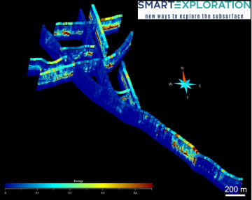
Active/passive seismic methods of surface wave analysis: surface wave processing and inversion techniques for a wide range of applications (e.g., mineral exploration, exploration of raw materials and geo-resources, seismic hazard characterization, verification of the integrity of embankments and linear infrastructures), automatic techniques for processing and interpretation of seismic data, even in real time and for fast site assessments.
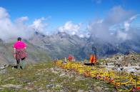
Characterization and monitoring of natural hazards, cryosphere and high altitude environments, and infrastructures with the vision of adapting to climate change: characterization of snow/ice volumes with electromagnetic methods, reconstruction of the thickness and basal morphology of glaciers, monitoring, and modeling of glacial evolution. Multi-methodological investigations for the characterization of landslides, periglacial and permafrost environments, and the monitoring of exposed infrastructures. Monitoring and early-warning techniques for natural hazards based on the analysis of environmental seismic noise and microseismicity, for the identification of seismic precursors to failure.
Geophysical characterization and monitoring for the energy transition: multi-methodological investigations (including magnetotellurics) for the characterization of low, medium and high enthalpy geothermal areas, innovative computational intelligence and multi-objective optimization methods for 2D processing and inversion and 3D geophysical data. Deep geophysical investigations for the characterization and monitoring of CO2 storage sites (CCS).
Geophysical characterization of contaminated sites and monitoring of remediation measures: electrical and electromagnetic investigations in contaminated sites, monitoring the degree of the contamination, the paths of the contaminants and the effectiveness of the remediation methods adopted, and comparative tests in the laboratory.
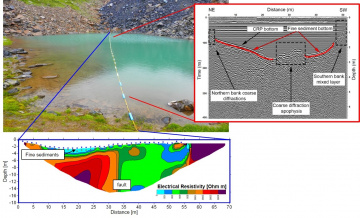
Geophysics in an aquatic environment: electrical, magnetic, electromagnetic, and acoustic investigations in shallow inland waters (lakes and rivers) for geological and hydrogeological characterization (e.g., using a flat-bottomed motorboat).
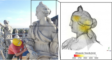
Archaeogeophysics and microgeophysics: magnetic/electromagnetic investigations in archaeological sites for the non-destructive identification of buried objects and structures, ultrasonic, magnetic and radar investigations on artefacts and buildings of the historical-cultural heritage for the assessment of structural integrity and the adoption of protection and restoration measures.
|
|
|
|
- COLOMBERO CHIARA
- GODIO ALBERTO
- PACE FRANCESCA
- SOCCO LAURA
- KHOSRO ANJOM FARBOD