cc-glacier-lab
Coordinator: Prof. Alberto Godio
Presentation
The study of the evolution of glacial masses is one of the classic areas in the monitoring of climate change, due to their sensitivity and vulnerability to thermal dynamics. The cc-glacier-lab is a multisite laboratory dedicated to the monitoring of glacial masses with innovative methodologies.
In particular, activities cover:
- survey of glaciers using integrated geomatics, aerial, terrestrial and satellite techniques with a multi-temporal approach to assess dimensional, volumetric and radiometric variations
- three-dimensional and time-dependent reconstruction and modelling of glacial masses
- monitoring of snow-ice interactions on a large scale, using information acquired from satellite platforms, and on a small scale, by geophysical measurements using georadar measurement campaigns, including those integrated with seismic methods
- estimation of front and supraglacial flow rates by thickness and surface shapes monitoring
- monitoring at local and regional level of the intensity and distribution of snowfall, of the measured temperatures on glacial masses and of the snow-water equivalent (on a basin scale)
- study of materials and technologies for controlling and minimizing the melting of ice.
- characterization of surface melting water paths, underground water infiltration analysis, also through installation of flow meters and tracer tests.
Ongoing projects and activities
• Effects of solid transport in periglacial environments as a result of climate change and fallout on dams
• Multidisciplinary approach to the study of endoglacial phenomena and mass balances
News
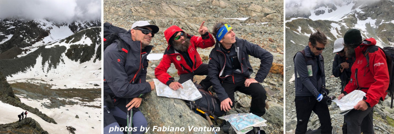
- In July 2022, a scientific expedition of the GlacierLab reached again Rutor glacier together with experts from ARPA Valle d’Aosta, to conduct new surveys. Here a short reportage of the activities that were carried out by the team
- In July 2021, the GlacierLab multidisciplinary team made three expeditions to the base of the Rutor Glacier in the Aosta Valley. The monitoring is carried out by means of point measurements campaigns and the installation of fixed instrumentation to study the water balance, the release of solid material, transport and sediment formation. Hydraulics, geomatics and geophysics techniques are involved.
- On July 24th the "Alpi 2020" expedition of the project Sulle Tracce dei Ghiacciai started (DIATI is one of the scientific partners). The Glacierlab research team was actively engaged in measurement campaigns in some of the stages of the expedition, in particular in Gressoney, Macugnaga and on Calderone glacier: https://poliflash.polito.it/ricerca_e_innovazione/sulle_tracce_dei_ghiacciai_nella_spedizione_alpi_2020_coinvolto_il_glacierlab_del_diati
- At the beginning of June 2020, a survey was carried out in Valpelline to plan a measurement campaign on 3 glaciers.